weather France Col de Coste Rouge
  • 15 day forecast

    -4° -6°
Day

Hourly weather

Cyrille DUCHESNE

Forecast produced by Cyrille DUCHESNE

Updated at - Next update at (local time)

Map settings
Models

We offer our satellite and rain radar maps of Col de Coste Rouge and its surroundings.
Follow the movements, in real time, of clouds and rain in Provence-Alpes-Côte d'Azur.
Enable lightning strikes to track the movement of storms.

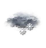
Snow from 3:10 am to 2 pm, a risk continues until tomorrow 7 am.

Thursday 17


  • 5 min + 03h
  • 03h10
  • 03h15
  • 03h20
  • 03h25
  • 03h30
  • 03h35
  • 03h40
  • 03h45
  • 03h50
  • 5 min + 03h55
  • 5 min + 04h
  • 5 min + 04h
  • 04h05
  • 04h10
  • 04h15
  • 04h20
  • 04h25
  • 04h30
  • 04h35
  • 04h40
  • 04h45
  • 04h50
  • 5 min + 04h55
  • 05h
  • 06h
  • 07h
  • 08h
  • 09h
  • 10h
  • 11h
  • 12h
  • 13h
  • 14h
  • 15h
  • 16h
  • 17h
  • 18h
  • 19h
  • 20h
  • 21h
  • 22h
  • 23h
  • 00h
  • 01h
  • 02h
  • 03h
Time Temperature Rain Wind
  • Low Moderate
  • Light snow falls Risk 100% Light snowfall Calm Gusts 20
  • Light snow falls Risk 100% Light snowfall Calm Gusts 10
  • Light snow falls Risk 100% Light snowfall Calm Gusts 15
  • Light snow falls Risk 100% Light snowfall Calm Gusts 15
  • Light snow falls Risk 100% Light snowfall Calm Gusts 15
  • Snow showers, or developing snow Risk 100% Snow showers Calm Gusts 15
  • Light snow falls Risk 100% Light snowfall Calm Gusts 15
  • Snow showers, or developing snow Risk 100% Snow showers Calm Gusts 20
  • Snow showers, or developing snow Risk 100% Snow showers Calm Gusts 20
  • Snow showers, or developing snow Risk 100% Snow showers Calm Gusts 20
  • Snow showers, or developing snow Risk 100% Snow showers Calm Gusts 20
  • Light snow falls Risk 100% Light snowfall S 10 km/h Gusts 30
  • Light snow falls Risk 100% Light snowfall Calm Gusts 20
  • Light snow falls Risk 100% Light snowfall S 10 km/h Gusts 25
  • Light snow falls Risk 100% Light snowfall S 10 km/h Gusts 25
  • Light snow falls Risk 100% Light snowfall S 10 km/h Gusts 25
  • Light snow falls Risk 100% Light snowfall S 10 km/h Gusts 25
  • Light snow falls Risk 100% Light snowfall S 10 km/h Gusts 25
  • Light snow falls Risk 100% Light snowfall SW 10 km/h Gusts 25
  • Light snow falls Risk 100% Light snowfall SW 10 km/h Gusts 30
  • Light snow falls Risk 100% Light snowfall SW 10 km/h Gusts 30
  • Light snow falls Risk 100% Light snowfall SW 10 km/h Gusts 30
  • Snow showers, or developing snow Risk 100% Snow showers SW 10 km/h Gusts 30
  • Snow showers, or developing snow Risk 100% Snow showers SW 10 km/h Gusts 30
  • Snow falls Risk 80% Snowfall N 15 km/h Gusts 45
  • Snow falls Risk 80% Snowfall N 15 km/h Gusts 45
  • Snow falls Risk 80% Snowfall N 15 km/h Gusts 45
  • Snow falls Risk 80% Snowfall N 20 km/h Gusts 55
  • Snow falls Risk 70% Snowfall N 20 km/h Gusts 50
  • Snow falls Risk 70% Snowfall N 20 km/h Gusts 45
  • Snow falls Risk 70% Snowfall N 20 km/h Gusts 45
  • Snow falls Risk 75% Snowfall N 20 km/h Gusts 45
  • Snow falls Risk 100% Snowfall N 20 km/h Gusts 50
  • Overcast Risk 45% Chance of snow NE 20 km/h Gusts 45
  • Overcast Risk 45% Chance of snow N 10 km/h Gusts 35
  • Overcast Risk 35% Chance of snow N 10 km/h Gusts 30
  • Overcast Risk 30% Chance of snow NW 15 km/h Gusts 30
  • Overcast Risk 30% Chance of snow NW 15 km/h Gusts 30
  • Overcast and misty Risk 20% Chance of snow NW 15 km/h Gusts 25
  • Overcast and misty Risk 20% Chance of snow N 10 km/h Gusts 20
  • Overcast and misty Risk 20% Chance of snow N 10 km/h Gusts 20
  • Overcast Risk 35% Chance of snow NW 10 km/h Gusts 20
  • Overcast Risk 40% Chance of snow NW 10 km/h Gusts 20
  • Overcast Risk 45% Chance of snow N 10 km/h Gusts 20
  • Very cloudy Risk 35% Chance of snow N 10 km/h Gusts 20
  • Very cloudy Risk 25% Slight chance of a shower N 10 km/h Gusts 20
  • Very cloudy Risk 20% Slight chance of a shower NW 10 km/h Gusts 20
  • 50% 30% 10% 1900 20% 1000 lm uv 4 Moderate 44% Comfortable 1027 hPa excellent > 20 km excellent
  • 50% 30% 10% 1900 20% 1000 lm uv 4 Moderate 44% Comfortable 1027 hPa excellent > 20 km excellent
  • 50% 30% 10% 1900 20% 1000 lm uv 4 Moderate 44% Comfortable 1027 hPa excellent > 20 km excellent
  • 50% 30% 10% 1900 20% 1000 lm uv 4 Moderate 44% Comfortable 1027 hPa excellent > 20 km excellent
  • 50% 30% 10% 1900 20% 1000 lm uv 4 Moderate 44% Comfortable 1027 hPa excellent > 20 km excellent
  • 50% 30% 10% 1900 20% 1000 lm uv 4 Moderate 44% Comfortable 1027 hPa excellent > 20 km excellent
  • 50% 30% 10% 1900 20% 1000 lm uv 4 Moderate 44% Comfortable 1027 hPa excellent > 20 km excellent
  • 50% 30% 10% 1900 20% 1000 lm uv 4 Moderate 44% Comfortable 1027 hPa excellent > 20 km excellent
  • 50% 30% 10% 1900 20% 1000 lm uv 4 Moderate 44% Comfortable 1027 hPa excellent > 20 km excellent
  • 50% 30% 10% 1900 20% 1000 lm uv 4 Moderate 44% Comfortable 1027 hPa excellent > 20 km excellent
  • 50% 30% 10% 1900 20% 1000 lm uv 4 Moderate 44% Comfortable 1027 hPa excellent > 20 km excellent
  • 50% 30% 10% 1900 20% 1000 lm uv 4 Moderate 44% Comfortable 1027 hPa excellent > 20 km excellent
  • 50% 30% 10% 1900 20% 1000 lm uv 4 Moderate 44% Comfortable 1027 hPa excellent > 20 km excellent
  • 50% 30% 10% 1900 20% 1000 lm uv 4 Moderate 44% Comfortable 1027 hPa excellent > 20 km excellent
  • 50% 30% 10% 1900 20% 1000 lm uv 4 Moderate 44% Comfortable 1027 hPa excellent > 20 km excellent
  • 50% 30% 10% 1900 20% 1000 lm uv 4 Moderate 44% Comfortable 1027 hPa excellent > 20 km excellent
  • 50% 30% 10% 1900 20% 1000 lm uv 4 Moderate 44% Comfortable 1027 hPa excellent > 20 km excellent
  • 50% 30% 10% 1900 20% 1000 lm uv 4 Moderate 44% Comfortable 1027 hPa excellent > 20 km excellent
  • 50% 30% 10% 1900 20% 1000 lm uv 4 Moderate 44% Comfortable 1027 hPa excellent > 20 km excellent
  • 50% 30% 10% 1900 20% 1000 lm uv 4 Moderate 44% Comfortable 1027 hPa excellent > 20 km excellent
  • 50% 30% 10% 1900 20% 1000 lm uv 4 Moderate 44% Comfortable 1027 hPa excellent > 20 km excellent
  • 50% 30% 10% 1900 20% 1000 lm uv 4 Moderate 44% Comfortable 1027 hPa excellent > 20 km excellent
  • 50% 30% 10% 1900 20% 1000 lm uv 4 Moderate 44% Comfortable 1027 hPa excellent > 20 km excellent
  • 50% 30% 10% 1900 20% 1000 lm uv 4 Moderate 44% Comfortable 1027 hPa excellent > 20 km excellent
  • 50% 30% 10% 1900 20% 1000 lm uv 4 Moderate 44% Comfortable 1027 hPa excellent > 20 km excellent
  • 50% 30% 10% 1900 20% 1000 lm uv 4 Moderate 44% Comfortable 1027 hPa excellent > 20 km excellent
  • 50% 30% 10% 1900 20% 1000 lm uv 4 Moderate 44% Comfortable 1027 hPa excellent > 20 km excellent
  • 50% 30% 10% 1900 20% 1000 lm uv 4 Moderate 44% Comfortable 1027 hPa excellent > 20 km excellent
  • 50% 30% 10% 1900 20% 1000 lm uv 4 Moderate 44% Comfortable 1027 hPa excellent > 20 km excellent
  • 50% 30% 10% 1900 20% 1000 lm uv 4 Moderate 44% Comfortable 1027 hPa excellent > 20 km excellent
  • 50% 30% 10% 1900 20% 1000 lm uv 4 Moderate 44% Comfortable 1027 hPa excellent > 20 km excellent
  • 50% 30% 10% 1900 20% 1000 lm uv 4 Moderate 44% Comfortable 1027 hPa excellent > 20 km excellent
  • 50% 30% 10% 1900 20% 1000 lm uv 4 Moderate 44% Comfortable 1027 hPa excellent > 20 km excellent
  • 50% 30% 10% 1900 20% 1000 lm uv 4 Moderate 44% Comfortable 1027 hPa excellent > 20 km excellent
  • 50% 30% 10% 1900 20% 1000 lm uv 4 Moderate 44% Comfortable 1027 hPa excellent > 20 km excellent
  • 50% 30% 10% 1900 20% 1000 lm uv 4 Moderate 44% Comfortable 1027 hPa excellent > 20 km excellent
  • 50% 30% 10% 1900 20% 1000 lm uv 4 Moderate 44% Comfortable 1027 hPa excellent > 20 km excellent
  • 50% 30% 10% 1900 20% 1000 lm uv 4 Moderate 44% Comfortable 1027 hPa excellent > 20 km excellent
  • 50% 30% 10% 1900 20% 1000 lm uv 4 Moderate 44% Comfortable 1027 hPa excellent > 20 km excellent
  • 50% 30% 10% 1900 20% 1000 lm uv 4 Moderate 44% Comfortable 1027 hPa excellent > 20 km excellent
  • 50% 30% 10% 1900 20% 1000 lm uv 4 Moderate 44% Comfortable 1027 hPa excellent > 20 km excellent
  • 50% 30% 10% 1900 20% 1000 lm uv 4 Moderate 44% Comfortable 1027 hPa excellent > 20 km excellent
  • 50% 30% 10% 1900 20% 1000 lm uv 4 Moderate 44% Comfortable 1027 hPa excellent > 20 km excellent
  • 50% 30% 10% 1900 20% 1000 lm uv 4 Moderate 44% Comfortable 1027 hPa excellent > 20 km excellent
  • 50% 30% 10% 1900 20% 1000 lm uv 4 Moderate 44% Comfortable 1027 hPa excellent > 20 km excellent
  • 50% 30% 10% 1900 20% 1000 lm uv 4 Moderate 44% Comfortable 1027 hPa excellent > 20 km excellent
  • 50% 30% 10% 1900 20% 1000 lm uv 4 Moderate 44% Comfortable 1027 hPa excellent > 20 km excellent
These parameters are reserved for subscribers.
You have 50% to discover:

Precipitation amount, cloud cover, light index, UV index, air humidity, air pressure and visibility.
logo VIP
  • Faster browsing
  • Detailed weather forecast
  • No ads
  • Access to Live TV

CLIMATE info


Rain

-20%
normal
Less rain than normal
Water restriction:
No restrictions

Temperature

-4°C
normal
Colder than normal
Normal temperature : -1°C
Average, today : -5°C
One year ago : -7°C

Drought

0/5
No drought
Fire-risk indicator
Risk Low

Ephemeris


Thursday 17 april

  • Day
    +3 min
  • Waning
    gibbous Moon
  • Sunrise
    06h45
  • Sunset
    20h22
  • Stephen Harding

Next few days


Near Col de Coste Rouge